openelab.de
 openelab.com


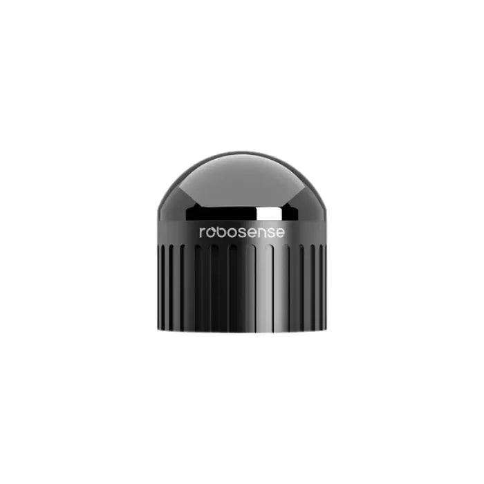


When RoboSense unveiled the Fairy, the LiDAR industry took notice — and for good reason. Described as the world's first high-precision mid-to-long-range digital LiDAR, this sensor isn't just an iterative improvement over what's come before. It's a fundamentally different approach to how mid-range 3D point cloud sensing is architected. After thoroughly reviewing its technical specifications, design philosophy, and real-world application data, that claim holds up under scrutiny.
Whether you're developing L4 autonomous vehicles, deploying smart city infrastructure, or engineering next-generation logistics robots, the Fairy represents a meaningful leap over conventional mechanical scanning approaches. This review walks through exactly what makes it different, what the numbers actually mean, and where it earns its keep in demanding real-world deployments.

What Is the RoboSense Fairy?
The RoboSense Fairy is a compact, 96-beam (also available in 48-beam) 3D LiDAR sensor built on RoboSense's proprietary chip-based transceiver architecture. Unlike traditional mechanical LiDAR designs that rely on physically spinning laser assemblies, the Fairy uses a fully digital transmission and reception pipeline — pairing a next-generation VCSEL (Vertical-Cavity Surface-Emitting Laser) emitter chip with a high-photon-efficiency SPAD-SoC (Single-Photon Avalanche Diode System-on-Chip) receiver.
The result is a sensor delivering industry-leading 0.5 cm ranging repeatability, weighing less than 350 grams, and fitting within a cylindrical form factor of just φ75 × H70 mm. For the mid-to-long-range category, that's a remarkable combination of performance and physical compactness — and it's why the Fairy has attracted attention across autonomous vehicle development, logistics automation, and smart infrastructure teams.
RoboSense Fairy Full Specifications
Here is a comprehensive breakdown of the Fairy's verified technical parameters, sourced directly from RoboSense's official documentation:
| Specification | Value |
|---|---|
| Beam Configuration | 96-beam / 48-beam |
| Point Cloud Density (96-beam, single return) | ~1,370,000 pts/s |
| Point Cloud Density (48-beam) | ~685,000 pts/s |
| Detection Range | 150 m @ 10% reflectivity |
| Field of View (H × V) | 360° × 32° |
| Angular Resolution | 0.25° × 0.33° |
| Ranging Repeatability (1σ) | 0.5 cm |
| Dimensions | φ75 × H70 mm |
| Weight | <350 g |
| Integrated IMU | Yes |
| Interfaces | Ethernet, PPS / NMEA GPS sync |
| Laser / Detector Architecture | VCSEL emitter + SPAD-SoC receiver (digital) |
| All-Weather Operation | Yes — rain, fog, night, strong sunlight |
The 0.5 cm (1σ) repeatability figure is the headline number for good reason. For context, most mid-range mechanical LiDARs operate with ranging accuracy in the ±2–5 cm range. The Fairy's precision isn't a modest incremental gain — it's a fundamentally different order of magnitude, and it's enabled entirely by the digital architecture at the sensor's core.
Digital LiDAR vs. Mechanical LiDAR: Why Architecture Matters
The transition from mechanical to digital LiDAR is one of the defining architectural shifts in 3D sensing technology over the past five years. Understanding what "digital" actually means here is important for evaluating where the Fairy fits in a real system stack.
How Mechanical LiDAR Works — and Where It Falls Short
Traditional mechanical LiDARs work by physically rotating a set of laser emitters and photodetectors around a vertical axis. The spinning assembly sweeps a 360° field of view, firing laser pulses and measuring time-of-flight for each return. This approach works, but it carries significant structural trade-offs:
- Mechanical wear: Rotating assemblies with bearings, slip rings, and motor components introduce failure modes absent in chip-based designs. Vibration, shock loads, and thermal cycling accelerate degradation over time.
- Size and mass penalties: Motor assemblies add bulk. Most mechanical mid-range LiDARs weigh between 600 g and 1.5 kg — a meaningful payload penalty for drones or compact robots.
- Analog signal chain limitations: Traditional designs use analog amplification and comparison circuits that introduce noise and temperature-dependent drift, constraining practical precision to ±2–5 cm in field conditions.
- Calibration drift: Mechanical alignment between emitter and detector arrays shifts over time, requiring periodic recalibration in high-precision applications.
How the Fairy's Digital Architecture Changes the Equation
Digital LiDAR architectures replace the analog signal chain with a chip-based digital pipeline, end to end:
- VCSEL emitters produce tightly controlled, fast-pulsed laser beams with excellent beam quality, minimal thermal drift, and high electrical-to-optical conversion efficiency. Each pulse is precisely timed at the chip level, eliminating jitter from analog drive circuits.
- SPAD-SoC receivers detect individual photons with nanosecond resolution. The SoC integration means time-of-flight measurements are quantized digitally at the point of detection, eliminating the noise floor of analog amplification entirely.
- Simplified signal processing: With a digital pipeline, the signal path from emission trigger to ranging output is substantially simpler, improving both noise immunity and system reliability.
- Higher point cloud density per unit weight: Chip integration allows significantly more beam channels in a smaller package than mechanical designs can achieve at equivalent weight.
The practical outcome is clear: the Fairy achieves 0.5 cm repeatability versus 2–5 cm for typical mechanical alternatives, generates ~1.37 million points per second (96-beam) versus 320,000–700,000 pts/s from comparable mechanical units, and achieves this in a sub-350 g package that would be impossible with conventional motor-driven designs.

Key Features in Depth
0.5 cm Ultra-High Ranging Precision
The 0.5 cm (1σ) repeatability figure means the Fairy can reliably distinguish objects separated by less than a centimeter at operational distances. In practice, this enables fine-grained obstacle detection — power lines, thin fencing, traffic cones, narrow pallet slots — that is invisible or ambiguous to lower-precision sensors. For SLAM (Simultaneous Localization and Mapping) algorithms and high-definition 3D map construction, this precision dramatically reduces accumulated error over extended traversals and allows more confident landmark association.
It's worth noting the measurement conditions for this spec: 30°C outdoor temperature, target range 0.5 m to 70 m, 50% target reflectivity, averaged across channels 25 to 72. Real-world precision at extreme ranges or low-reflectivity targets will be lower, but the fundamental capability is well ahead of the mechanical LiDAR field.
96-Beam, 1.37 Million Points Per Second
The 96-beam configuration generates approximately 1.37 million points per second in single-return mode. This is roughly 170% higher point cloud density than a standard 32-beam mid-range LiDAR. That density increase directly translates to more reliable object detection at distance, richer inputs for semantic segmentation models, and more accurate localization in cluttered or featureless environments — exactly the conditions where lower-density sensors tend to fail.
Full 360° × 32° Field of View
The Fairy covers a complete horizontal panorama with a 32° vertical aperture. That vertical span is wider than many competing sensors in its size class, enabling better detection of road surface features at close range alongside overhanging obstacles at height. For mobile robots navigating complex indoor/outdoor environments or vehicles managing mixed traffic scenarios, this FOV balance is carefully considered and practically useful.
Compact and Lightweight: φ75 × H70 mm, Under 350 g
At less than 350 grams with a cylindrical profile of 75 mm diameter and 70 mm height, the Fairy is, by RoboSense's own characterization, the lightest mid-to-long-range digital LiDAR commercially available. This matters immediately for drone payload budgets, handheld mapping systems, and small autonomous platforms where gram-level mass accounting affects battery life and dynamic performance. The compact form factor also simplifies mounting and structural integration into existing robot chassis designs that weren't sized for a conventional LiDAR turret.
Integrated IMU for Motion Compensation
An on-board inertial measurement unit is a practical engineering win that's easy to underestimate. IMU data synchronized with the point cloud stream enables real-time motion compensation during fast platform movement — critical for accurate 3D mapping from drones or high-speed ground robots where platform attitude changes between scan lines. Many competing LiDAR modules require external IMU integration, adding cabling complexity, synchronization latency, and calibration burden. Having it built in reduces integration effort and improves data quality out of the box.
All-Weather Operational Robustness
The Fairy's active illumination technology means it operates entirely independently of ambient light conditions. Rain, fog, intense direct sunlight, and complete darkness — conditions that routinely challenge passive camera systems — have no material impact on the Fairy's point cloud quality. For outdoor autonomous systems targeting 24/7 operational uptime, this isn't a nice-to-have feature; it's a baseline requirement, and the Fairy delivers it reliably.
Real-World Use Cases
L4 Autonomous Driving and Autonomous Mobile Robots
The Fairy's combination of precision and point cloud density positions it well for L4 autonomous vehicle perception stacks. At this autonomy level, the vehicle must handle all driving tasks without human intervention within its defined operational design domain. The 150 m detection range provides adequate look-ahead distance at urban and suburban speeds, while the 0.5 cm precision supports accurate object classification and tracking at close range — the near-field challenge that many long-range LiDARs struggle with due to angular resolution constraints at short distances.
For autonomous mobile robots (AMRs) operating in warehouses, hospitals, or mixed-use campuses, the Fairy's compact form factor and high-precision localization capabilities enable reliable navigation in dynamic, human-populated spaces where sensor placement options are often constrained.
Smart Logistics and Autonomous Forklifts
Autonomous forklifts and goods-transport robots face a particularly demanding sensing environment: high-precision localization in cluttered warehouse spaces, detection of narrow pallet slots at close range, avoidance of human workers and transient obstacles, and continuous multi-shift operation. The Fairy addresses each of these requirements:
- 0.5 cm precision supports pallet-slot detection and precise approach positioning.
- 1.37M pts/s density enables reliable pedestrian and small-obstacle detection in dense environments.
- Under 350 g weight reduces the impact on the vehicle's payload capacity.
- All-weather operation ensures consistent performance in outdoor loading bays and mixed indoor/outdoor logistics facilities.
- Integrated IMU simplifies motion compensation during forklift acceleration and deceleration phases.
Smart City and Infrastructure Monitoring
Smart port terminals, traffic monitoring systems, urban intersection controllers, and logistics hub access management are increasingly deploying LiDAR as a primary sensing modality for vehicle classification, pedestrian tracking, and event detection. The Fairy's full 360° coverage, high point cloud density, and fine angular resolution make it well-suited for these fixed-mount infrastructure applications. The Ethernet interface and PPS/NMEA GPS synchronization support seamless integration into networked infrastructure systems with precise time-stamping for event correlation across sensor arrays.
Drone-Based Mapping and Survey
Weighing under 350 g, the Fairy is one of the few mid-to-long-range LiDARs that can be practically integrated into professional survey drones without compromising flight endurance or triggering regulatory payload limits. The integrated IMU and GPS sync interfaces further simplify integration with standard drone autopilot systems. For terrain mapping, powerline inspection, forestry inventory, and precision agriculture applications, the combination of 150 m range, sub-centimeter repeatability, 1.37M pts/s density, and full 360° coverage in a sub-350 g package is genuinely difficult to match with current alternatives.
Integration and Ecosystem Considerations
The Fairy connects via Ethernet for point cloud data streaming — a well-supported interface in robotics middleware. PPS and NMEA GPS synchronization are supported for applications requiring precise time-stamping. The sensor's structured point cloud output is explicitly optimized for algorithm consumption, enabling real-time object detection, SLAM, and semantic segmentation pipelines without additional preprocessing overhead.
ROS and ROS 2 driver support is available from RoboSense, making the integration pathway for robotics development teams straightforward. For infrastructure and industrial applications, the Ethernet interface supports direct integration into standard industrial networking environments.
You can explore full integration documentation and request product details on the RoboSense Fairy product page at OpenELAB.
Who Is the RoboSense Fairy Designed For?
The Fairy is designed for engineering teams who have outgrown what entry-level mechanical LiDARs can offer, but who need a sensor that fits within real-world size, weight, and integration constraints. If your application demands precise 3D point clouds at mid-range distances, reliable all-weather performance, and a sensor that won't dominate your platform's payload budget, the Fairy is worth serious evaluation.
It's particularly relevant for:
- Robotics startups and OEMs developing L4 AMR or AGV platforms for logistics and service applications
- Drone manufacturers targeting precision mapping, inspection, and survey markets
- Smart infrastructure integrators deploying LiDAR-based monitoring at fixed installations
- Autonomous mining and port vehicle developers requiring 24/7 all-weather reliability
- Research institutions working on high-density SLAM, semantic mapping, and autonomous perception algorithms
Frequently Asked Questions
What makes the RoboSense Fairy a "digital" LiDAR?
The Fairy uses a fully digital architecture from laser emission through to point cloud output. VCSEL chips handle emission with precise digital timing; SPAD-SoC chips handle photon detection and time-of-flight measurement at the chip level. There is no analog intermediate stage in the measurement pipeline. This digital architecture is what enables the 0.5 cm ranging repeatability that mechanical designs cannot match.
How does the Fairy's 0.5 cm precision compare to other mid-range LiDARs?
Most mid-range mechanical LiDARs achieve ranging accuracy in the ±2–5 cm range under field conditions. The Fairy's 0.5 cm (1σ) repeatability is significantly better — it's currently the highest-precision mid-to-long-range LiDAR in its size and weight class.
What is the maximum detection range?
The Fairy achieves a maximum detection range of 150 m at 10% reflectivity — a standard industry benchmark using a dark, low-reflectivity target. At higher reflectivity targets (such as road marking retroreflectors or white panels), operational range will be correspondingly greater.
Does the Fairy work in rain and fog?
Yes. The Fairy uses active laser illumination and is not dependent on ambient lighting. It maintains reliable operation in rain, fog, strong direct sunlight, and complete darkness. Performance in extreme precipitation conditions (heavy rain, dense fog) will vary with atmospheric attenuation, as with all LiDAR sensors.
What interfaces does the Fairy support?
The Fairy connects via Ethernet for point cloud data streaming. PPS (Pulse Per Second) and NMEA GPS synchronization interfaces are supported for precise time-stamping. This makes integration with standard robotics middleware (ROS/ROS 2) and networked infrastructure monitoring systems straightforward.
Is a 48-beam version available?
Yes. The Fairy is available in both 96-beam (~1,370,000 pts/s) and 48-beam (~685,000 pts/s) configurations. The 48-beam version allows engineering teams to balance point cloud density against processing load and system cost for applications where the full 96-beam density exceeds requirements.
How light is the Fairy compared to competing sensors?
The Fairy weighs less than 350 grams, making it the lightest mid-to-long-range digital LiDAR in its performance class. Comparable mechanical mid-range LiDARs typically weigh 600 g to 1.5 kg. This difference is significant for drone payload planning and compact robot chassis integration.
Does the Fairy have an integrated IMU?
Yes. An IMU is integrated into the Fairy, providing synchronized inertial data alongside the point cloud stream. This enables motion compensation during fast platform movement — particularly valuable for drone-based mapping and high-speed ground robot applications.
Conclusion
The RoboSense Fairy earns its "world's first" designation not through marketing positioning, but through a genuine architectural achievement. By combining VCSEL emission with SPAD-SoC detection in a fully digital pipeline — and packaging the result in a sub-350 g, φ75 × H70 mm form factor — RoboSense has delivered a mid-to-long-range sensor that is simultaneously more precise, lighter, and more capable than what the mechanical LiDAR market has offered at this range class.
For engineering teams building the next generation of autonomous robots, logistics vehicles, smart city infrastructure, and survey drones, the Fairy represents a clear and practical step forward in what's achievable in a field-deployable LiDAR package. The 0.5 cm precision, 1.37 million points per second, and integrated IMU in under 350 g is a combination that wasn't available before — and it opens up application designs that previously required compromises on precision, payload, or cost.
Explore the RoboSense Fairy Mid-Range Digital LiDAR at OpenELAB to learn more about integration options, compatibility documentation, and availability.